
STRATEOLE-2 Project
STRATEOLE-2 is a project dedicated to the study of atmospheric phenomena at the Earth's equator. Led by CNES with international participation, it utilizes stratospheric balloons capable of flying for over 3 months at altitudes between 18 and 20 km.
Project Scope
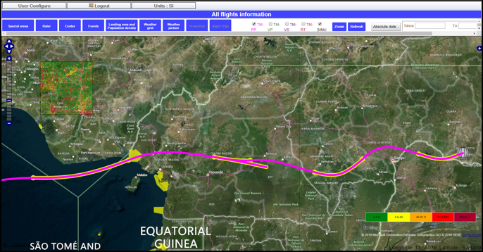
The balloons can fly over up to 77 countries, making population safety a constant priority. Operations are managed from the CASIMIR Control Center at the Toulouse Space Center, with support from local antennas in Aire-sur-l'Adour and at release sites.
Learn more about STRATEOLE-2ALBERIX Platform
R.Tech developed the ALBERIX web server to enable real-time tracking of balloon positions and access to their historical trajectories. Connected to a PostgreSQL database, this tool offers CNES teams a comprehensive suite of features for balloon flight management.
Real-time Tracking
Live monitoring of balloon positions and historical trajectories
Advanced Mapping
Integration with OpenStreetMap and custom CNES map layers
Alert System
Real-time alerts from various Control Center tools
Weather Integration
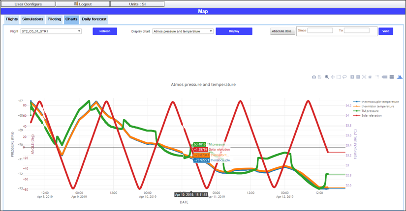
Loading and analysis of weather files for flight planning
LISA Library
The ALBERIX software relies on the LISA library, developed by R.Tech, to integrate flight physics directly into the core of the application. LISA is a Java library dedicated to flight physics modeling, providing a comprehensive framework for balloon flight simulation and analysis.
Flight Physics Modeling
Comprehensive modeling for all types of balloons and flight phases
Trajectory Models
Advanced models for balloons, parachutes, and envelopes
Data Management
Handling of flight data, weather data, and post-processing capabilities
Flexible Configuration
Customizable internal models with extensive configuration options